


FAO soil classification
The food and Agriculture Organization of the United Nations (FAO) has developed a supranational classification that offers useful generalizations about soil formation regarding the interaction between major soil-forming factors. It was first published as a UNESCO World Soil map in 1974 (scale 1: 5 000 000).
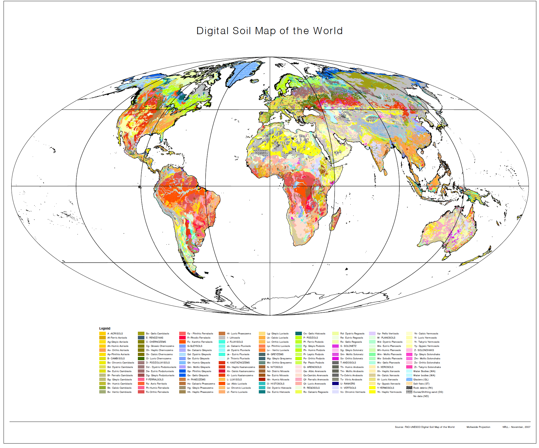
The history of creating a soil map of the world began in 1956, when at the 6th Congress of the International Union of Soil Science (IUSS) in Paris, it was decided to pay special attention to the development of classification and correlation of soils on large continents of the world. As a result, in 1960, at the 7th Congress in Madison (Wisconsin, USA), soil maps covering Africa, Australia, Asia, Europe, South America and North America were presented on a scale from 1:5,000,000 to 1:10,000,000. However, it soon became apparent that the nomenclature, survey methods, legends, and classification systems used in different regions were very different, making it difficult to compare. In response to the recommendation of the Congress and recognizing the need for comprehensive knowledge of the world’s soils, FAO and UNESCO agreed in 1961 to prepare a joint map of the world’s soils in cooperation with the International Union of Soil Science on a scale of 1:5,000,000. The project was implemented in 1974. It was the fruit of a worldwide collaboration of countless soil scientists, and until recently it remained the only global survey of soil resources.
The purpose of the soil map of the world was to:
– give the first assessment of the world’s soil resources;
– provide a scientific basis for the exchange of experience between territories with common environmental conditions;
– contribute to the establishment of a generally accepted soil classification and nomenclature;
– establish a common framework for more detailed research in developing territories;
– become the main document for activities in the field of education, research and development;
– strengthen international cooperation of soil scientists.
Developed as a legend for the soil map of the world, the classification was used in projects sponsored by the United Nations (UN). Many countries have modified this system to suit their needs.
The soil map consisted of 106 soil units, which are mapped as soil associations marked with the dominant soil unit:
– soil phases (soil properties such as rockiness, salinity, alkalinity, etc.);
– three texture classes (heavy, medium, and light);
– three slope classes (from flat to gentle, from steep to hilly, and from steep to mountainous).
In 1988, FAO published a “Revised legend” with 153 soil units, which forms the basis for the World harmonized soil database.
This system was later replaced by the world reference database of soil resources (WRB), the first edition of which was published at the 16th World Congress of Soil Science in Montpellier, France, in 1998. At the same event, it was also approved and adopted as a soil correlation and international communication system. The second edition of the WRB was published at the 18th World Congress in Philadelphia in 2006. Third edition WRB, which was published in 2014.